

Building on edge: Why Nigeria continues to build in floodplains, wetlands

By Adesina Jeremiah, Photojournalist & Climate Communicator
As climate change intensifies rainfall across Nigeria, the country’s rapid urban expansion continues to push homes, roads, and public infrastructure into flood-prone landscapes. This feature examines how architecture, environmental science, governance, and planning decisions are shaping a cycle of recurring floods in Lagos and Ogun states—and asks who should be held accountable.
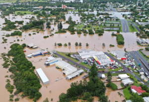
Before sunrise, floodwater still lingers in parts of Lekki Phase 1 and Orchid Road long after the rain has stopped. Inside nearby homes, residents move mattresses onto tables, lift electrical appliances onto shelves, and sweep muddy water from their living rooms.
Children wait to see if the roads to school will be passable, while shop owners count another day’s losses before opening their doors. For many, flooding is no longer an unexpected disaster; it has become part of the rhythm of the rainy season.
These scenes have become increasingly familiar in one of Nigeria’s fastest-growing urban corridors. Yet, even as floodwaters return with remarkable consistency, cranes continue to rise above reclaimed land, new estates break ground, and roads extend deeper into landscapes that once absorbed excess rainfall.
The question is no longer whether Nigeria will flood each rainy season. It is why homes, roads, and estates continue to be built where flooding is increasingly predictable.
Wetlands are often mistaken for empty land waiting to be developed. In reality, they are among nature’s most effective flood defence systems. They absorb rainfall, slow the movement of stormwater, replenish groundwater, and reduce the intensity of floods before engineered drainage systems are called upon. Once these wetlands are replaced with concrete, asphalt, and sand-filled developments, the water does not disappear; it simply changes direction, often ending up inside homes, schools, markets, and businesses.
Nowhere is this contradiction more evident than in Lagos. Built on a network of lagoons, creeks, and coastal wetlands, the city has expanded rapidly to meet the demands of a growing population and one of Africa’s largest urban economies. Over the years, marshlands have given way to luxury estates, commercial hubs, highways, and major infrastructure projects, particularly across the Lekki-Epe Corridor.
While these developments have fuelled investment and economic growth, they have also reduced the natural landscapes that once acted as buffers against flooding.
Across the border in Ogun State, the story echoes with a different geography but similar consequences. Communities in Arepo, Warewa, Kara, and other settlements adjoining Lagos experience recurrent flooding driven by rapid urbanisation, inadequate drainage networks, blocked waterways, and seasonal releases from upstream dams.
For many residents, rebuilding after floods has become an annual ritual rather than an emergency response.
Climate change has undoubtedly intensified rainfall across West Africa, but it does not fully explain the scale of Nigeria’s urban flooding. Researchers studying land-use change in Lagos consistently point to another factor: decades of wetland reclamation, fragmented urban planning, weak enforcement of physical planning regulations, and drainage systems struggling to keep pace with the speed of development. Nature has changed, but so too has the landscape engineered by people.
These realities raise difficult questions about accountability. If flood-risk maps exist and environmental impact assessments are required before major developments proceed, why do projects continue to emerge in areas long recognised as environmentally sensitive? Satellite imagery analysed by researchers has documented the steady conversion of wetlands into built-up areas across parts of Lagos over the past several decades.
The transformation reflects the city’s remarkable growth, but it also highlights the environmental trade-offs that are becoming increasingly difficult to ignore.
The cost of these decisions extends far beyond damaged buildings.
Floodwaters contaminate drinking water, force schools to close, interrupt healthcare services, destroy inventory in small businesses, and leave families facing repair costs they cannot afford. For households without insurance or substantial savings, a single flood can erase years of financial progress within hours.
Nigeria’s cities need housing. They need roads, transport infrastructure, and economic opportunities. Few dispute that reality. What urban planners, architects, and environmental scientists increasingly argue, however, is that development must be guided by the landscapes it transforms rather than imposed upon them. Protecting wetlands, enforcing planning regulations, investing in resilient drainage systems, and integrating flood-risk assessments into every major development are not barriers to progress—they are essential to building cities capable of withstanding a changing climate.
Ultimately, this is not merely a story about heavy rainfall or climate change. It is a story about governance, planning, and the choices that shape the future of Nigeria’s cities.
Every wetland reclaimed without adequate safeguards, every drainage channel neglected, and every development approved without sufficient regard for flood risk increases the likelihood that the next downpour will become another headline.
The families lifting mattresses onto tables in Lekki today are not waiting for the rain to stop. They are waiting for a future in which development respects the landscapes that have protected communities for generations.
Until Nigeria begins treating wetlands not as vacant land but as critical infrastructure, flooding will remain more than a natural disaster; it will remain a consequence of decisions made long before the first clouds gather.



Ebola scare: APC defends N10bn emergency fund, faults Atiku’s criticism
Chinedum Ukaegbu All Progressive Congress (APC), Presidential Campaig…